Galápagos Islands South American Continent

Galápagos Islands South American Continent

The Galápagos Islands are an archipelago of volcanic islands distributed on either side of the Equator in the Pacific Ocean, 926 km (575 mi) west of continental Ecuador, of which they are a part.
The Galápagos Islands and their surrounding waters form an Ecuadorian province, a national park, and a biological marine reserve. The principal language on the islands is Spanish. The islands have a population of slightly over 25,000.
The islands are famed for their vast number of endemic species and were studied by Charles Darwin during the voyage of the Beagle. His observations and collections contributed to the inception of Darwin’s theory of evolution by natural selection.
The first recorded visit to the islands happened by chance in 1535, when the Bishop of Panamá Fray Tomás de Berlanga went to Peru to arbitrate in a dispute between Francisco Pizarro and Diego de Almagro. De Berlanga was blown off course, though he eventually returned to the Spanish Empire and described the conditions of the islands and the animals that inhabited them. The group of islands was shown and named in Abraham Ortelius’s atlas published in 1570. The first crude map of the islands was made in 1684 by the buccaneer Ambrose Cowley, who named the individual islands after some of his fellow pirates or after British royalty and noblemen. These names were used in the authoritative navigation charts of the islands prepared during the Beagle survey under captain Robert Fitzroy, and in Darwin’s popular book The Voyage of the Beagle. The then new Republic of Ecuador took the islands from Spanish ownership in 1832, and subsequently gave the islands official Spanish names. The older names remained in use in English language publications, including Herman Melville’s The Encantadas of 1854.

Fairy Pools, Isle of Skye, Scotland

Fairy Pools, Isle of Skye, Scotland

The Isle of Skye is a gem of an island, lying off the west coast of Scotland, with beautiful mountain scenery, interesting geology, stunning sea lochs and plenty of wildlife.

It’s also just become the first place in the world to be ‘virtually twinned’ after being twinned with the fictional isles of Skylands as part of the promotion of the new Skylanders video game.
Skye is the largest of the Inner Hebrides lying of the west coast of Scotland and its landscape is distinctly Highland with its lochs, heather-clad moors and towering peaks.

Despite its small size, Skye boasts an impressive 20 Munros, making the island a favourite with hillwalkers keen to tackle the heights of its Cuillin mountain range. The Black Cuillin is famous for its dramatic jagged ridge and the Inaccessible Pinnacle, a 150 ft rock making Sgurr Dearg the only Munro in Scotland with a summit that can only be reached by rock climbing.

Under the shadow of the towering Black Cuillin lies Loch Coruisk. With its reflective waters and mountain scenery, the loch is considered to be one of the most beautiful sights in Scotland.

Aside from the Munros, Skye features many other geological marvels such as the breathtaking landslip formation, the Quiraing, the astounding sea cliff of Kilt Rock on the rocky coastline of Trotternish, and strange rock pinnacles like the Old Man of Storr. The Faerie Pools of Glenbrittle are fast becoming a popular place for a swim thanks to its beautiful clear waters and spectacular surrounding scenery.

It was this beautiful scenery that led to the recent unique twinning partnership between the Isle of Skye and the virtual world of Skylands. In the world’s first every ‘virtual twinning’, Skye has provided some of the backdrop for the exciting new Skylander SWAP Force game, with key character Wash Buckler already having visited the island. The game brings toys to life by combining the physical characters playing in a virtual word with the ability to swap the top and bottom halves of the interactive figures.

Skye’s scenic landscape also provides a home for an abundant array of wildlife. Red deer, Scottish wildcats, pine martens and mountain hares roam the hillsides while around the coast you are sure to spot seabirds, seals and, if you are lucky, otters. In summer, why not take a boat trip, where you may catch a glimpse of dolphins, sea eagles and golden eagles? There are several companies providing boats trips around Skye, including Misty Isle Boat Trips, Elgol Boat Trips and Bella Jane Boat Trips.

Cinque Terre, Rio Maggiore, Italy

Cinque Terre, Rio Maggiore, Italy

Riomaggiore is a village and comune in the province of La Spezia, situated in a small valley in the Liguria region of Italy. It is the first of the Cinque Terre one meets when travelling north from La Spezia.
The village, dating from the early thirteenth century, is known for its historic character and its wine, produced by the town’s vineyards. Riomaggiore is in the Riviera di Levante region and has shoreline on the Mediterranean’s Gulf of Genoa, with a small beach and a wharf framed by tower houses. Riomaggiore’s main street is Via Colombo, where numerous restaurants, bars and shops can be found.
The Via dell’Amore is a path connecting Riomaggiore to its frazione Manarola, also part of the Cinque Terre.
Riomaggiore is the most southern village of the five Cinque Terre, all connected by trail. The water and mountainside have been declared national parks.
Riomaggiore inspired paintings by Telemaco Signorini (1835-1901), one of the artists of the Macchiaioli group.

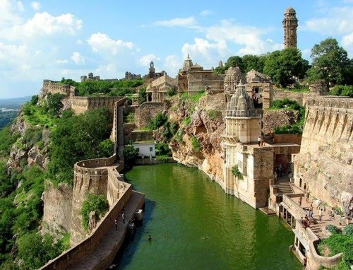
Chittorgarh Fort, India

Chittorgarh Fort, India

Chittorgarh Fort is the largest fort in India and the grandest in the state of Rajasthan. The fort, plainly known as Chittor, was the capital of Mewar and is today situated several kilometres by road south of Bhilwara. It was ruled initially by Guhilot and later by Sisodias, the Suryavanshi clans of Chattari Rajputs, from the 7th century, until it was finally abandoned in 1568 after the siege by Emperor Akbar in 1567. It sprawls majestically over a hill 180 m (590.6 ft) in height spread over an area of 280 ha (691.9 acres) above the plains of the valley drained by the Berach River. The fort precinct with an evocative history is studded with a series of historical palaces, gates, temples and two prominent commemoration towers. These monumental ruins have inspired the imagination of tourists and writers for centuries.
The fort was sacked three times between the 15th and 16th centuries; in 1303 Allauddin Khilji defeated Rana Ratan Singh, in 1535 Bahadur Shah, the Sultan of Gujarat defeated Bikramjeet Singh and in 1567 Emperor Akbar defeated Maharana Udai Singh II who left the fort and founded Udaipur. Each time the men fought bravely rushing out of the fort walls charging the enemy but lost every time. Following these defeats, Jauhar was committed thrice by more than 13,000 ladies and children of the Rajput heroes who laid their lives in battles at Chittorgarh Fort, first led by Rani Padmini wife of Rana Rattan Singh who was killed in the battle in 1303, and later by Rani Karnavati in 1537 AD.
Thus, the fort represents the quintessence of tribute to the nationalism, courage, medieval chivalry and sacrifice exhibited by the Mewar rulers of Sisodia and their kinsmen and women and children, between the 7th and 16th centuries. The rulers, their soldiers, the women folk of royalty and the commoners considered death as a better option than dishonor in the face of surrender to the foreign invading armies.

Hiller lake, Western Australia

Hiller lake, Western Australia

Lake Hillier is a pink-colored lake on Middle Island, the largest of the islands and islets that make up the Recherche Archipelago, Western Australia. From above the lake appears a solid bubble gum pink. It is such a significant distinguishing feature of the archipelago that air passengers often crane their necks to take a glimpse of it.

The lake is about 600 meters long, and is surrounded by a rim of sand and a dense woodland of paperbark and eucalyptus trees. A narrow strip of sand dunes covered by vegetation separates it to the north from the Southern Ocean.